Urban Order & Public Space Design
A Brief in preparation for Acoustic Arenas & Urban Space Theory
The previous posts provided the reasoning for the study hypothesis and addressed the research question, “Is it possible to develop a public space design model derived from acoustical phenomena and aural spatial qualities?” The second research question is, “If so, how is the urban morphology of the public space reflected in aural spatial patterns, and what principles determine these formations?” To answer this question, the next research post briefly discusses the intersecting research fields; specifically, urban design and aural spatial awareness.
Urban design theory is a large and intricate field. This post discusses the aspects that pertain to the research topic, including urban order, growth morphology and network configuration. In the abstract, aural spatial awareness research considers how spaces are perceived aurally and determines what design manipulation techniques are needed during the design process. In the next post, an urban sonic discourse follows and draws parallels between urban and aural design elements, such as soundmarks and soundscapes. These urban sonic features are explained in terms of their significance in urban settings and symbiotic relationships with urban order, growth morphology and network patterns.
Urban Order & Public Space Design
Cities are unique in that each has a recognisable ‘city shapeness’ and a general pattern that result from a common unit order that defines it as a city (MARSHALL, Stephen, 2008). The city emerges as the primary environment of the human species. One reoccurring research topic is the sonic character of a city, specifically, curbing noise pollution levels and restricting undesirable sound-level penetration in interior spaces.
Before discussing the uniqueness of the sonic pressure of a city and factors that define urban aural design, this post addresses the nature of cities to develop an understanding of structure and functional design. Modern cities have more complex soundscapes that are often planned features. Marshall (2008) argues that traditional urbanism functions better at the human scale and provides better public spaces for citizens to interact. This research examines historic traditional cities with pedestrian-friendly streets and public squares (plazas, piazzas, or courtyards) to examine receivers’ (i.e., humans) responses to the morphology and sonic events of the space.
Ancient city plans, such as those in nineteenth-century Europe and adapted ancient Roman cities are initially planned but growth patterns do not show any signs of pre-design. As a whole, these cities seem to have city shapeness or an identifiable urban morphology. This morphology is a result of the association between individual units. The complex aggregation of these units (streets and building blocks) creates urban public space patterns and networks (MARSHALL, Stephen, 2008). Conversely, traditional Islamic cities do not have formally institutionalised planning, which results in amorphic patterns of growth that emerge around built archetypes. Friday mosques, embedded in a framework of central markets fulfil institutional functions. No specific morphological growth pattern exists in Islamic cities; rather, they develop according to site constraints, community size, economic resources and building materials (BIANCA, Stefano, 2000).
Damascus, an ancient North African city, retains the inner morphological affinities of the earliest Arab cities. When appropriated, Damascus was planned per Roman traditional town-planning regulations with a strict grid layout and main axial roads. With the Islamic adaptation, the grid was no longer the governing factor of the morphology of public spaces or residential districts. The main roads started to secede into smaller pedestrian parallel paths around small market structures. Privacy became the deciding factor in creating a broken flow of successive hierarchal streets that ended in courtyards. This shift led to inward-oriented autonomous units that formed around courtyards. Research suggests that traditional communities centre on religious beliefs (Muslim, Christian, or any other) materialise their environments to reflect the individual perceptions of universal truth (BIANCA, Stefano, 2000). This definition is relevant to the current study in which sonic events originating from the foci of communities infiltrate private residential districts and define their sonic characters.
Design Theory
Designers across the spectrum of spatial scale tackle design problems by addressing how fundamental units work together; architectural elemental units include spatial components such as rooms and circulating corridors. Urban designers use similar components at a larger scale (building blocks and public urban spaces).
Design units are the indivisible components that would lose functional integrity if fragmented. In other words, units are unable to exist independently; they only function as an aggregation of other urban units. For example, a room cannot function in isolation; rather, the composite of rooms acts as a subcomponent arranged in a determined order to form a building, and the building forms an urban unit. If the dimensions of one subcomponent (e.g., room) are multiplied the unit may act as self-sufficient (small building or cabin) (MARSHALL, Stephen, 2008).
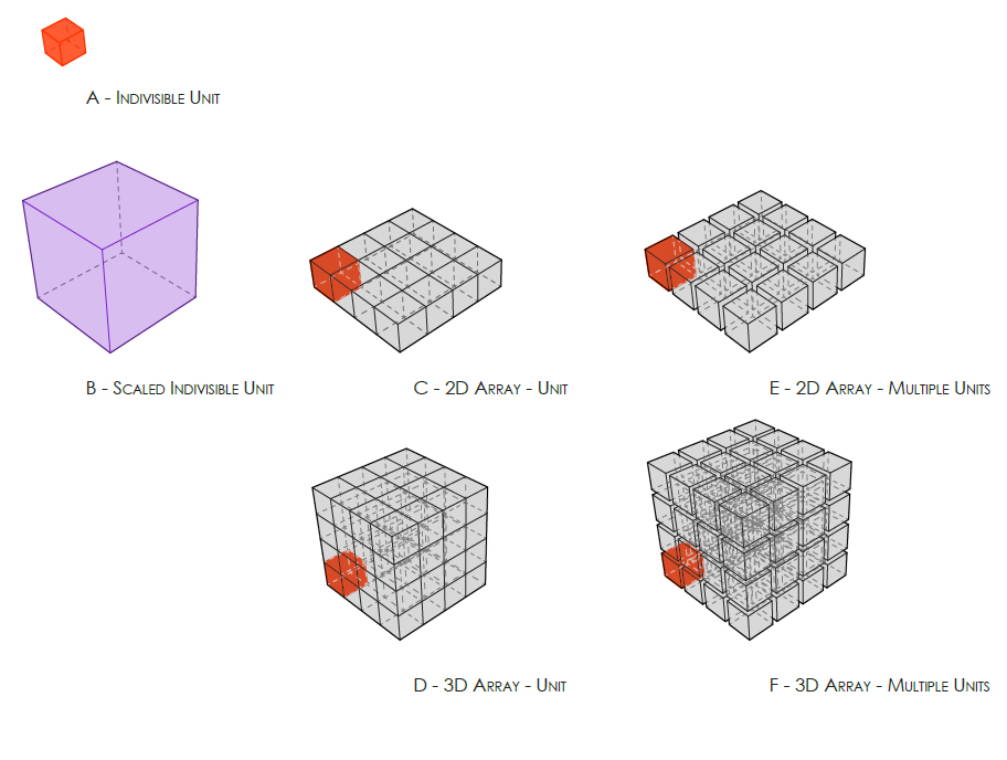
An adapted diagram of Sub-component Aggregation. (a) A sub-component can not be a stand-alone element (b) If a sub-component’s dimensions are increased it can act as a ’whole’. (c) A two-dimensional array of subcomponents assembling a complete component, with the ground as a common datum (d) A three-dimensional array of sub-component assembling a complete component (building) (e) A two-dimensional array, where sub-components are aggregated with intermittent ‘void’- (public space), moving into urban scale. (f) A three-dimensional array of sub-component, where subcomponents are aggregated with intermittent ‘void’ – against gravity Original Image Reference: (Marshall, Cities, Design & Evolution, 2008).
Buildings are designed around interior artificial environments designed at a human scale, which is determined by the size of the average human in an upright position. The form of interior spaces is not a coffin-like box influenced by this defining measurable scale and number of humans. Rather, form is derived from the psychological and intellectual characters of inhabiting users and social activities. When the same subcomponent is repeated in a straightforward two-dimensional or complex three-dimensional array, a unit structure, such as a city block or building, evolves at a larger scale. Even though the number of atomic units increases, the overall cell maintains a state of ‘wholeness,’ as with a building. Similarly, buildings assembled in two-dimensional arrangements become subcomponents of a more complex ‘whole’ or urban fabric (MARSHALL, Stephen, 2008).
When the subcomponents become part of the urban fabric, the system is transferred from a building scale to an urban scale. The two-dimensional aggregation of the building blocks generates an indivisible unit (void or streets) without which the nature of the new unit could not exist. If buildings are constructed adjacently, without streets and public spaces, the result is a larger building block, not an urban fabric. The size and form of a building or urban fabric is a derivation of the size, number and aggregation system of the subcomponents (MARSHALL, Stephen, 2008). Theoretically, a three-dimensional version of this solid-void system is possible; however, gravitational forces render it impractical. This discussion does not consider this impractically, but it is referenced in the following section with a discussion on aural design. Aural spatial units follow the same logic in which the activity held and the number of users in the domain determines the unseen boundaries.
Order and Growth
Prior to modern communication and transportation growth factors, the sonic character of a city was coherent. Consistent indications infer the effect of sound on the morphological growth of old townships and the formation of city edges. The strongest defining sound customarily originated from the centre of the town (BLESSER, Barry and Salter, Linda-Ruth, 2006). Therefore, it is pivotal to understand the basic concept and defining factors of urban growth.
Urban growth is ‘human-shaped’ and based on a social logic and theoretical order of building blocks and streets. A society is a group of humans who vary in gender, generation, and economic statuses and co-exist by abiding by a contract. Such agreement states that all parties (everyone in society) agree to limit some of their freedoms (MARSHALL, Stephen, 2008). Despite the differences in regional climates, cultures, technologies and economies, urban forms are diversely evident over space and time.
Urban order goes beyond the abstract unit typologies of buildings and public voids; it is also defined by users’ purposes (i.e., programmatic use). Social groups (communities/neighbourhoods) and social units (family/workplace) are units that contribute to urban order, form and growth. Similar to the physical spatial units of cities, these units are the building blocks of society that have hierarchical structure. Buildings form around the social organisation and define the relation between social and spatial structures. For example, the form of a Greek amphitheatre reflects the relationship between the performers and the audience. Because of this relationship, buildings grow and become more complex as social units increase in size and complexity.
Various practical and social factors can prevent indefinite growth (MARSHALL, Stephen, 2008). Cities are like living organisms; larger animals have different forms compared to smaller ones (STEADMAN, Philip, 2008). Unlike a building, city growth morphology is not only a monolithic aggregation of buildings; it grows as a textured fabric. As the system grows beyond sustainability, the resulting strain forces the settlement to become a larger social container or a city with distinct urban patches. In turn, urban patches (districts) become aggregating subunits of a city that form around social groups (MARSHALL, Stephen, 2008).
Concentric city growth is the most frequent morphology in which inner centralised higher functions are surrounded by lower and newer ones. This typically unplanned tradition is found in the irregular aggregation of street pattern shapes, which occur at different lengths and angles. Traditional cities implement a planned systematic order at the urban fabric scale. The corresponding fundamental units demonstrate a correlated pattern to each other, as they do to the whole city. The social structure of the city follows a characteristic, rather than systematic, order. Areas inhabited by similar social groups (e.g., ethnic backgrounds or economic status) are directly identified as communities or neighbourhoods. Thresholds between these neighbourhoods become blurred and separate urban patches with different morphological characteristics, which are the direct result of the social groups inhabiting these patches (MARSHALL, Stephen, 2008).
![An adapted diagram of urban order. [Top] Systematic order: a set of objects, or units, have the same relationship with respect to each other. [Bottom] Characteristic order: a rough type of order that typically is found in un-planned order. Original …](https://images.squarespace-cdn.com/content/v1/56aec9178259b53131dd94a8/1457667480689-EEQJ0OXMPDC1IMV1VUSC/image-asset.jpeg)
An adapted diagram of urban order. [Top] Systematic order: a set of objects, or units, have the same relationship with respect to each other. [Bottom] Characteristic order: a rough type of order that typically is found in un-planned order. Original Image Reference: (Marshall, Cities, Design & Evolution, 2008)
Networking
Studying street networks and patterns provides an understanding of urban growth and morphology (MARSHALL, Stephen, 2005). Structurally, a city is an organisational network similar to the internet. The structure differs from other organisational networks in that it has a common planar datum that grounds it into a two-dimensional plane. Street and urban space networks are arguably a contributing factor to better city design. Space networks are system units or single lines that create the signature skeletal structure of the city. Thus, the network structure depends on the contiguity of these linear elements (MARSHALL, Stephen, 2008).
Historically, central places and main routes illustrate a reverse relation to modern planned cities. Markets, plazas and squares are urban circulation cores, and the intensity of the circulation dissipates outward from the foci. Movement is the main programmatic function of spaces created between city blocks. Spatial organization and the morphology of these ‘movement spaces’ is a direct result of the information flow, geometry and connectivity topology (MARSHALL, Stephen, 2005).
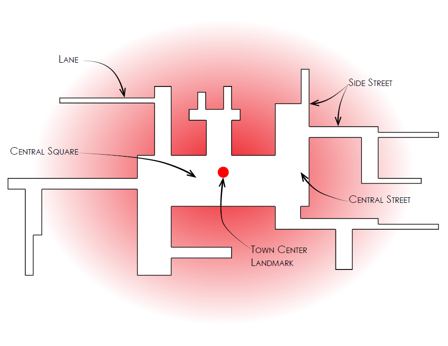
An abstract diagram of historic settlement structure. The market square holds a central position, and the circulation intensity attenuates further away from the core. The routes closer to periphery of the town are of relatively lower hierarchical levels. Original Image Reference: (Marshall, Streets and Patterns, 2005)
Characteristically, urban networks are arranged in a hierarchical fractal structure, and principal arterial streets are connected strategically to form a single network. Lower-order streets feed off this system but are not necessarily totally connected (MARSHALL, Stephen, 2005). The characteristic connectivity of streets highlights these elements as the components that create the urban network structure. Although this structure may appear irregular, it is a systematic order known as urban syntax (MARSHALL, Stephen, 2008).
Urban design research designates various classifications and descriptors for urban network patterns. Some descriptors refer to street configurations or intersection topologies, while others refer to the alignment of streets and urban spaces. Marshall (2005) argues that recognised sets depend on the target of study [1]. He also points out that urban morphology classification requires emphasising the geometry of formed blocks. The case studies considered in this research warrant discussing Marshall’s A-type (Altstadt) network topology, which is typical of old walled cities with angular routes oriented in various directions. Often, this pattern topology is seen as the core of the city, and rudimentarily grows radially outward. As a result, the configuration of the urban network may have high connectivity, but it is characteristically impermeable (MARSHALL, Stephen, 2005).
![An adapted diagram A-Type [Altstadt] street pattern. Is typical of the core area of old cities. The angularity of routes, oriented in a variety of directions, generates a rudimentary radially, where such a pattern is located at the core of a settlem…](https://images.squarespace-cdn.com/content/v1/56aec9178259b53131dd94a8/1457668003160-LWRSX88Q8TWKXERX9Q8I/image-asset.jpeg)
An adapted diagram A-Type [Altstadt] street pattern. Is typical of the core area of old cities. The angularity of routes, oriented in a variety of directions, generates a rudimentary radially, where such a pattern is located at the core of a settlement. [Top-Left] Mixture of configuration properties (Tand X-junctions, some cul-de-sac; moderate connectivity. [Middl-Left] Irregular, fine scale angular, streets mostly short or crooked, varying in width, going in all directions. [Bottom-Left] Composition of the built areas [Right] Types of constitutional structure [conjoint] arterial without access constraint. Original Image Reference: (Marshall, Streets and Patterns, 2005)
![An adapted diagram of permeability and connectivity. [Left] Greater permeability [Middle] Less permeability [Right] Both have the same connectivity. Original Image Reference: (Marshall, Streets and Patterns, 2005)](https://images.squarespace-cdn.com/content/v1/56aec9178259b53131dd94a8/1457668091704-HQ9YEOZVCS59L6WAA0PG/image-asset.jpeg)
An adapted diagram of permeability and connectivity. [Left] Greater permeability [Middle] Less permeability [Right] Both have the same connectivity. Original Image Reference: (Marshall, Streets and Patterns, 2005)
Public Spaces & Interstitial Spaces
Only when both streets and buildings exist can a city substantiate. Streets and public spaces are not just the void between buildings; they are urban units and are a part of the urban social fabric. Public spaces are designed as void volume that is circumscribed by the vertical elements of a city. In general, cities have significant vertical dimensions; however, the ‘urban signature’ of a city is distinguished along a datum surface. Thus, city shapeness is better represented as a two-dimensional organisational plan. A typical city plan has a set of isolated similar areas (land parcels) surrounded by linear interdependent and interconnected elements (streets systems). This order is known as archipelagos, a system illustrated in the continents surrounded by oceans. The contiguity of street systems regulates urban order, and private plots connect directly to this contiguous network. Buildings located on these private plots house social groups comprised of various types of social units. The route network is a conjugating tissue of public spaces between these social groups (MARSHALL, Stephen, 2008).
![An adapted diagram of connectivity and order. [Top-Left] ‘Archipelago’ example, earth map. [Top-Right] Navigating the ‘archipelago’, All ports of call are connected by the continuum of public space. [Bottom-Left] Linear urban space, street. [Bottom-…](https://images.squarespace-cdn.com/content/v1/56aec9178259b53131dd94a8/1457668377080-OMJ8JTZ32HRYRU8C4480/image-asset.jpeg)
An adapted diagram of connectivity and order. [Top-Left] ‘Archipelago’ example, earth map. [Top-Right] Navigating the ‘archipelago’, All ports of call are connected by the continuum of public space. [Bottom-Left] Linear urban space, street. [Bottom-Right] Linear connectivity of urban space. Original Image Reference: (Marshall, Cities, Design & Evolution, 2008) (Marshall, Streets and Patterns, 2005)
Historically, public spaces have social character. For example, centralised squares, market places and main streets have a ‘people’s place’ role that is rich with diverse and complex programmatic responses to the social fabric. One can consider the visual morphology of a space as an ‘outdoor room’ with a direct relationship to the encircling buildings. Social asymmetries exist within social groups (the government and the governed), and they determine the hierarchical path of information flow (e.g., where and to whom certain information circulates). With advances in communication and transportation technologies, this social hierarchy may exist in a non-physical state, and the nature of the hierarchy and information flow trajectory define urban morphology (MARSHALL, Stephen, 2008).
Subtle social complexities and proximities result in the interpretation of private and public spaces. A public domain implies that it is an uncontrolled all-inclusive space. ‘Strangers’ do not need to behave according to certain rules other than popular social conventions. Public spaces are inclusive distinct foci where different social groups interact and communicate. The private-public order is a key social construct that manifests across the urban fabric and the programmatic use of the domain determines the topological order that forms the public space. Thus, a domain can be designed to encompass more than one or to be mutually exclusive.
The topology of a recognised public space is an all-inclusive space with segregated exclusive
subdomains. These subdomains have direct access to the all-inclusive space, which creates an
archipelago order. Nested topology is a more complex hierarchical configuration with a public-private gradient of residual inclusive domains that is determined by the programmatic use of the public space. Specifically, the design manipulates the physical attributes of the space to establish a hierarchy by employing subdividing barriers that do not need to be visually barring. For example, roping off a café sitting area with knee-high poles is sufficient to create an exclusive domain for patrons. A change in ground level is also a spatial filter. For example, in an assembly area, a stage or platform creates a social filter between the performers and the audience (MARSHALL, Stephen, 2008).
![An adapted diagram of private and public Domains. [Top-Left] Public all inclusive public space. [Top-Right] 2 exclusively private domains. [Bottom-Left] ‘archipelago’ ordered private sub-domains with direct access to an all-encompassing public space…](https://images.squarespace-cdn.com/content/v1/56aec9178259b53131dd94a8/1457668596351-4ZAHZ3T20AR3O58LBZ6S/image-asset.jpeg)
An adapted diagram of private and public Domains. [Top-Left] Public all inclusive public space. [Top-Right] 2 exclusively private domains. [Bottom-Left] ‘archipelago’ ordered private sub-domains with direct access to an all-encompassing public space. [Bottom -Right] Public-private gradient: Nested public spaces with caressingly exclusive restrictions. Original Image Reference: (Marshall, Cities, Design & Evolution, 2008)
[1] Stephen Marshall developed a network typology that reflects typical street patterns that are encountered in different kinds of urban analysis, namely ABCD typology. (A-type/Altstadt , B-type/Bilateral, C-type/conjoint, and D-type/Distributary) (MARSHALL, Stephen, 2005)